Cabinet Ridge
The Cabinet mountains are a small range of mountains in the northwest corner of Montana, just west of Libby, my wife's hometown. We made a weekend trip up to Libby so she could see her old friends. To save herself the embarrassment of anything her idiot husband might say, she sent me off on a long run over the Cabinet Ridge.
The original route suggested to me started at Flower Creek. With an incoming thunderstorm, Buzzy suggested that I instead start at Parmenter Creek because it would give me more options to run while staying in the trees and off the potentially dangerous ridgeline. Think about that for a moment. The forecast calls for rain and thunderstorms, and the idiot ultra runner does not give a second thought to NOT running. A few minutes into the run, and the weather looked a bit mild, so I took the cut-over from Parmenter to Flower Creek. End result is that I just prepended 4 miles to my route.
I couldn't determine how far the trail was on any online map. Using the old-school method of string on a paper map only gave a rough distance of ~20-25 miles. I ended up running approximately 28 miles over 8 hours, starting at 2400 ft and summiting at 7200 ft. Even with a watch, it's an approximate distance because I had to add up the watch track with a later phone track down Cedar Creek and the highway, and I paused the watch for a half hour and kept running like an idiot.
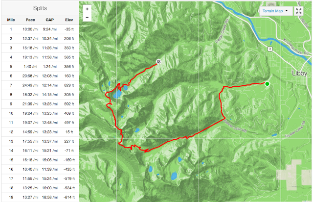 |
| Map of my route until watch battery died. |
In the first 2 miles, there were 3 water crossings - a notification that this better not be your first trail run. The trails here are technical. Large rocks, loose rocks and trip-enticing roots were everywhere. The trail was only barely wide enough for one person, sometimes for just one foot. And that's when you could see it. The picture below shows the trail. Do you see it? The leaves were soaking wet from earlier rain, and my shoes were sloshing water more from the brush than the water crossings. My feet would remain very wet the entire day.
With the rain, I didn't get a lot of views. Even though the trail goes up the ridge, I rarely saw more than 50 yards at a time, with just a few exceptions.
 |
| Looking up to the ridge |
 |
| Going up to the ridge |
The trail was probably more dangerous than I could see. When I got to the ridge, the trail dropped off abruptly, sometimes on both sides. But from what I could see, just 50 yards or so. There were patches of snow, of course. Some were easy to navigate, some weren't - they were steep slopes impossible to cross in running shoes. I had to circumnavigate downhill from one patch through loose shale scree, and then climb up through falling rock, all while hoping that I could find the trail on the other side that I couldn't see from the start.
 |
| Cut into the steep mountain-side |
 |
| Over, under, through the woods |
After 14 miles, I was finally awarded with a view of Cedar Lake. It was also reassuring that I wasn't lost up there. 5 hours so far and I hadn't seen a soul. I was finally headed downhill and to the finish. From the trailhead it was a fast few miles downhill on the fire road. I finally got a phone signal on the highway and called the wife to pick up her lazy husband who didn't want to run the whole highway back into town.
 |
| Cedar Lake from above |
 |
| Cedar Lake from the shore |
 |
| All wet. |


Comments
Post a Comment